“World Maps” is a politically and conceptually savvy exhibition featuring the work of Kim Abeles, Irene Dubrovsky, Joyce Kozloff and Ibrahim Miranda. The works on view investigate ideas of mapping, and the dissolution of borders and barriers between worlds. Each artist is represented by a sufficient body of work to allow for an in depth articulation of the theme and a back and forth between the selected images.
With the proliferation of the internet and the advent of Google Maps, the world has become a smaller place. Clicking a mouse allows one to visit the Arctic or fly through a city seeing both street and satellite views. Many artists have taken advantage of the mapping capabilities of digital technologies and created works that attempt to reduce the globe into a global network. The artists here may use what Google Maps and satellite photography have to offer as a means to pinpoint location, yet their works are about the transformation of that location into a painted, printed or sculpted object that fuses old and new technologies.
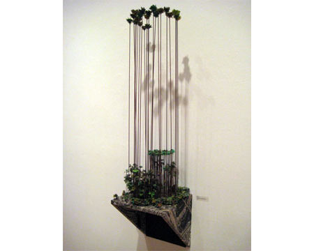
In her \"Signs of Life\" series Kim Abeles maps the location of trees in urban spaces. Three works from this series are presented in \"World Maps.\" “Looking for Paradise (one Tree for Each Tree Downtown)” creates a relationship between structures built by the city\'s nomadic homeless and the actual trees that exist in the urban landscape. In “Tall” and “Enchanted Forest - Dodger Stadium” model trees are integrated into platforms covered with satellite images of specific locations around Los Angeles. “Tall“ exaggerates the size of the trees that exist along the Newport Coastline, so that the tops of the trees tower above the landscape while their wire roots dangle below. No show on mapping that includes Abeles would be complete without the inclusion of a work from her ongoing Smog Collectors Series. In these pieces Abeles collects \'smog\' by placing a stencil of the image on her (or other\'s) rooftops allowing particles to fall from the air, becoming a darkened ground on the clear film. These images are later fixed, and in so doing become metaphors for the air we breathe.
While Abeles’ work is grounded in the nitty gritty of the urban landscape, Irene Dubrovsky makes ethereal landscapes that are woven maps based on images gleaned from visiting Google Earth. Each of Dubrovsky\'s works is a spiral that is the product of the weaving of strips of paper into a circular form that represents a view of the earth from above. The process of weaving creates a grid-like pattern that resembles the longitude and latitude lines on a map. The specific locations that Dubrovsky chooses to present include the Milky Way - both during the day and at night - the South Pole, The Constellations over the Antarctic, and the Amazon from her “Water Cartographies Series.” In each work the surface is built up through the presentation of folded paper to represent the changes in the natural landscape. The surface of the earth is described by the changes in color and height of the folded paper as well as by Dubrovsky\'s painted additions to the circular forms.
Joyce Kozloff\'s maps presented on globes and on hand-made paper masks depict voyages, either real or imagined. These voyages relate historic as well as contemporary narratives through the juxtaposition of brightly painted fragments comprised of text, maps and abstract patterns. Kozloff evokes collective memories associated with specific places. Each of the eight masks is isolated in its own white box, and titled after a specific voyage. They inform each other and expand the scope of Kozloff\'s project, but are meant to be scrutinized individually. The small masks and globes are intricate and full of detail. The two large wood block prints are more loosely painted abstractions of specific islands and the colors and patterns associated with each.
Ibrahim Miranda is a Cuban printmaker who has used old maps of Cuba as a ground on which he superimposes depictions of myths, religions, customs and cultures neglected in the originals. Interested in what history has left out, Miranda uses maps to create a new world view inclusive of what has been left out. He works with collage, drawing as well as printmaking to bring to light what is missing in the official depiction. His visually sophisticated works are simultaneously playful and informative.
There is a lot to look at and to ponder in \"World Maps.\" How maps define not only a world but a world view is investigated by all the artists in the exhibition.
Published courtesy of ArtSceneCal ©2010